See which assets need repair, in real time
The experts behind ReadyVIS provide custom utility asset inspection services with on-demand, cost-effective solutions for public and private utility customers — aerial imaging, photogrammetry, and 3D modeling through unmanned aircraft systems (UAS) and customized interactive software deliverables.
FAA Part 107 certified pilots · IBEW journeyman linemen
A data-driven inspection solution
Managing transmission and distribution assets is challenging. Developed specifically for utility providers, the ReadyVIS team offers an innovative, custom software solution and workflow for asset inspection and inventory.
Safer Inspections
Mandatory inspections of high voltage lines are often dangerous, time consuming, and expensive. ReadyVIS offers a safer, more efficient, and cost-saving option for public and private utility customers.
Data-Driven Deliverables
We don't just gather the data. We provide a full service, turnkey deliverable complete with conditional assessment of identified issues and recommendations for repair.
Expert Control
Our drone team is experienced flying T&D power lines, and every service is executed with certified journeyman linemen and qualified project managers — backed by the electrical expertise of IBEW linemen.
Services
Full service, turnkey deliverables for transmission and distribution infrastructure.
Storm Response & Damage Assessment
Lead Line Placement Over Difficult Terrain
Pre-Construction Site Survey & Mapping
Standard Line Inspection Survey
Vegetation Management Survey
Construction Progress Updates
ReadyVIS vs. Traditional Asset Inspection
- ✓Less expensive, reduced mob/demob costs
- ✓Safer, less impact from weather
- ✓Reduced touches for data management and input
- ✓More accurate information, less unnecessary maintenance
- ✓Ease of use, can add users easily
All your data in one seamless interface
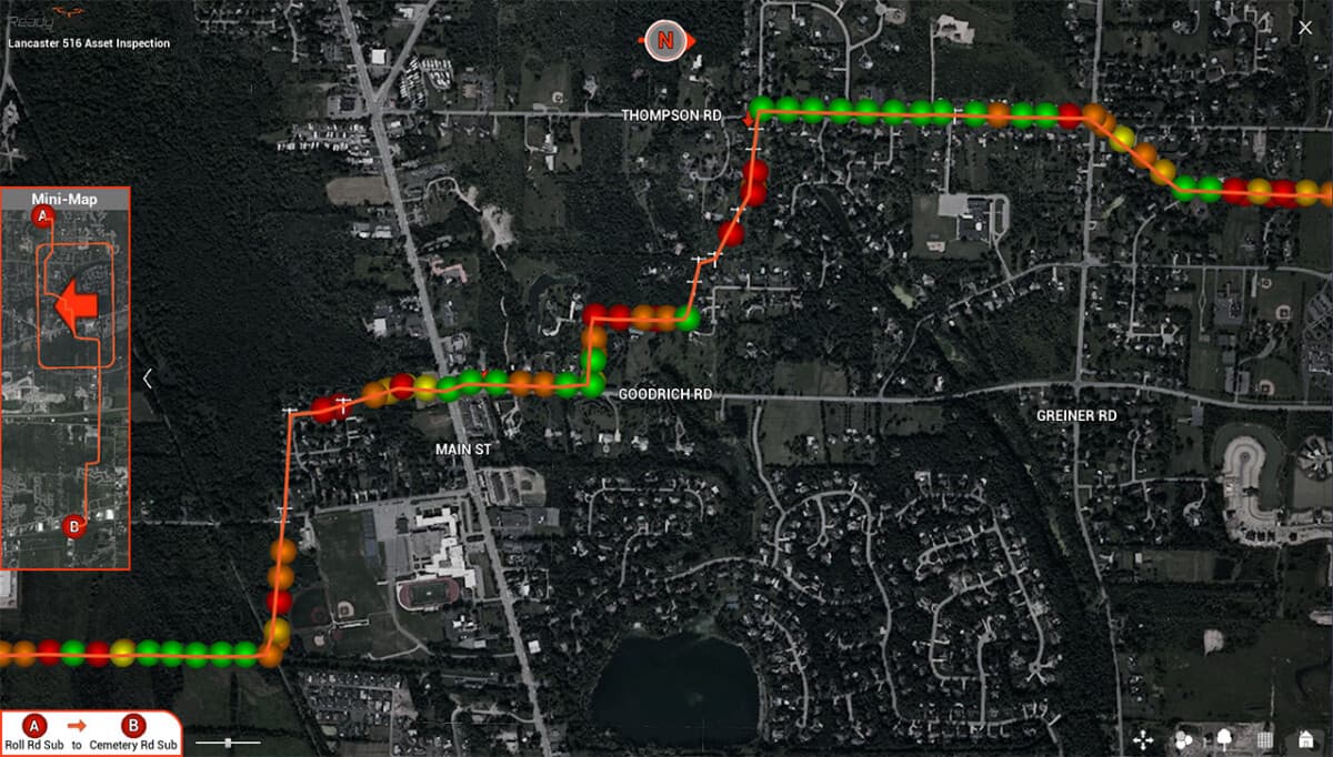
Offering drone services isn't the best part. Providing decision makers with usable data is what our customers expect — so you can get back to making decisions, not reviewing gigabytes of data.
System Features
- •House and manage all district and circuit data in one easy-to-navigate user interface
- •Showcase HD media (pictures/video) from the drone, directly accessible within the app
- •User-friendly interface with satellite imagery showing street and point-of-interest labels
- •Numerous viewing modes and user preference settings
- •One-click online mapping access for directions to asset locations
- •Data filtering providing user control of information visibility
Work Order Generation
Easily select from a list of assets or deficiencies, prepare and generate a PDF work order, then schedule field work and arrange for associated materials and labor.
Clear Zone Vegetation Analysis
Advanced vegetation analysis locates and quantifies the vegetation within the R.O.W. that poses risk to utility infrastructure. Synced drone video with real-world drone location provides a current birds-eye view of the actual surrounding vegetation correlating to the clear zone analysis.
Asset inspection data viewable in-app
- •Structure identification
- •Precise asset locations
- •HD drone images and videos
- •Analyzed condition and priority of deficiencies found
- •Estimated costs for repair or replacement
- •Record information of past inspections to easily track asset deterioration over time
Ready to see your assets in a new light?
Please connect with our expert support team to learn more. Let us know how we can help.